OLD TOWNS BOOKS & MAPS
Old Maps of Essex in 1773
Essentials for Local Historians, Genealogists & Family Historians
MODERN MAPS
LOOKING FOR A DETAILED MODERN ORDNANCE SURVEY MAP OF AN ESSEX TOWN? CLICK HERE
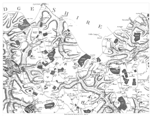
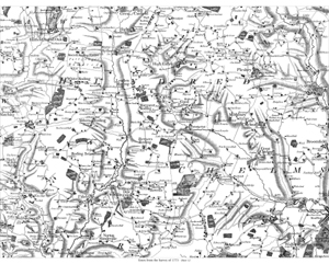
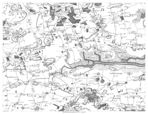
Essex 1773 Sheet 2
Saffron Walden to Steeple Bumpsted
Size: 20.5 x 15.5 inches
Scale: 1.75 inches/mile
Type: reproduction, flat sheet
CLICK MAP TO ENLARGE
PRICE: £9.99
This map shows: (spelling as per map) the area from Saffron Walden in the west to Steeple Bumpsted in the east of the map, and from Hadstock in the north to Debden in the south of the map.
Ridducks Hill is in the map centre.
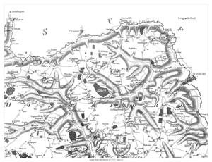
Essex 1773 Sheet 3
Stambourn to Middleton
Size: 20.5 x 15.5 inches
Scale: 1.75 inches/mile
Type: reproduction, flat sheet
CLICK MAP TO ENLARGE
PRICE: £9.99
This map shows: (spelling as per map) the area from Stambourn in the west to Middleton in the east of the map, and from Pentlow in the north to Sible Hedingham in the south of the map.
Ridducks Hill is in the map centre.
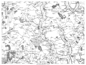
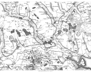
Essex 1773 Sheet 4
Dunmow area
Size: 20.5 x 15.5 inches
Scale: 1.75 inches/mile
Type: reproduction, flat sheet
CLICK MAP TO ENLARGE
PRICE: £9.99
Showing (spelling as per map) the area from Stansted-Monfichet in the west to Great Saling in the east of the map, and from Thaxted in the north to Barnston in the south of the map.
Great Easton is in the map centre.
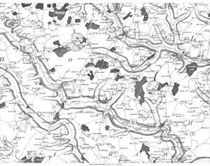
Essex 1773 Sheet 8
Braintree & Halstead area
Size: 20.5 x 15.5 inches
Scale: 1.75 inches/mile
Type: reproduction, flat sheet
CLICK MAP TO ENLARGE
PRICE: £9.99
This map shows: (spelling as per map) the area from Weathersfield in the west to Great Tey in the east of the map, and from Pebmarsh in the north to Cressing in the south of the map.
Rayne Hatch is in the map centre.
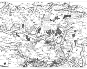
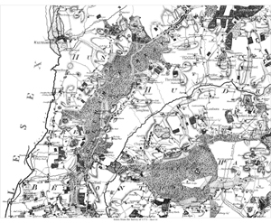
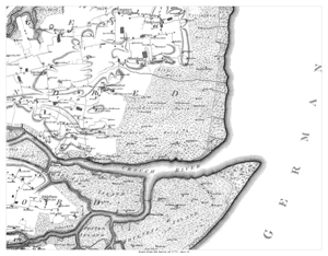
Essex 1773 Sheet 9
Colchester area
Size: 20.5 x 15.5 inches
Scale: 1.75 inches/mile
Type: reproduction, flat sheet
CLICK MAP TO ENLARGE
PRICE: £9.99
This map shows: (spelling as per map) the area from Aldham in the west to Elmsted in the east of the map, and from Dedham in the north to Fingringhoe in the south of the map.
Mile-End is in the map centre.
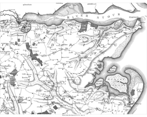
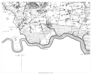
Essex 1773 Sheet 10
Manningtree & Harwich area
Size: 20.5 x 15.5 inches
Scale: 1.75 inches/mile
Type: reproduction, flat sheet
CLICK MAP TO ENLARGE
PRICE: £9.99
This map shows (spelling as per map) the area from Great Bromley in the west to Harwich in the east of the map, and from Maningtree in the north to Weeley in the south of the map.
Great Oakley is in the map centre.
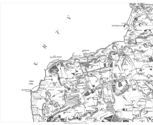
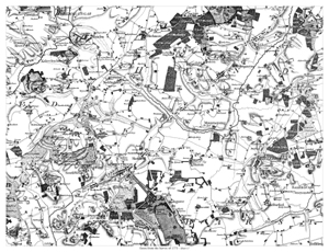
Essex 1773 Sheet 11
Harlow area
Size: 20.5 x 15.5 inches
Scale: 1.75 inches/mile
Type: reproduction, flat sheet
CLICK MAP TO ENLARGE
PRICE: £9.99
This map shows (spelling as per map) the area from Roydon in the west to Magdalen Laver in the east of the map, and from Harlow in the north to Weald Gullet in the south of the map.
Little Parndon is in the map centre.
Essex 1773 Sheet 12
Area north-west of Chelmsford
Size: 20.5 x 15.5 inches
Scale: 1.75 inches/mile
Type: reproduction, flat sheet
CLICK MAP TO ENLARGE
PRICE: £9.99
This map shows (spelling as per map) the area from Hatfield Heath in the west to Broomfield in the east of the map, and from Great Canfield in the north to Norton Mandeville in the south of the map.
Berners Roding is in the map centre.
Essex 1773 Sheet 13
Maldon & Witham area
Size: 20.5 x 15.5 inches
Scale: 1.75 inches/mile
Type: reproduction, flat sheet
CLICK MAP TO ENLARGE
PRICE: £9.99
This map shows (spelling as per map) the area from Little Waltham in the west to Little Totham in the east of the map, and from Kelvedon in the north to Woodham Mortimer in the south of the map.
Hatfield is in the map centre.
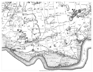
Essex 1773 Sheet 14
Wigborough & Mersea
Size: 20.5 x 15.5 inches
Scale: 1.75 inches/mile
Type: reproduction, flat sheet
CLICK MAP TO ENLARGE
PRICE: £9.99
This map shows: (spelling as per map) the area from Beckingham (Toleshunt Major) in the west to Brightlingsea in the east of the map, and from Langenhoe in the north to Bradwell in the south of the map.
West Mersea is in the map centre.
Essex 1773 Sheet 16
Chigwell area
Size: 20.5 x 15.5 inches
Scale: 1.75 inches/mile
Type: reproduction, flat sheet
CLICK MAP TO ENLARGE
PRICE: £9.99
This map shows (spelling as per map) Waltham Holy Cross, Epping, Stapleford Tany, Theydon Mount, Theydon Cernon, Theydon Bois, Sewardston, Chingford, Loughton, Abridge, Lamborn, Stapleford Abbots, Havering ate Bower, Chigwell, Woodford, Walthamstow, and part of Rumford (Romford) in the SE corner.
Essex 1773 Sheet 17
Brentwood & Billericay
Size: 20.5 x 15.5 inches
Scale: 1.75 inches/mile
Type: reproduction, flat sheet
CLICK MAP TO ENLARGE
PRICE: £9.99
This map shows (spelling as per map) Greensted, Stanford Rivers, Cheping Ongar (Chipping), Stondon, Blackmore, Stock, Butsbury, Margareting, Ingatestone, Frierning, Doddinghurst, Kelvedon-hatch, Navestock, Brentwood, Shenfield, Mountneysing, Hutton, Billericay, Ramsden Crays, Great Bursted, Little Bursted, Ingrave, South Weald
Essex 1773 Sheet 18
The Woodham Ferrers area
Size: 20.5 x 15.5 inches
Scale: 1.75 inches/mile
Type: reproduction, flat sheet
CLICK MAP TO ENLARGE
PRICE: £9.99
This map shows (spelling as per map) Haseley, Purley, Mundon, Snoreham, Lachingdon, Norton Cold, Stow Mareys, Woodham Ferrers, East Haningfield, West Haningfield, South Haningfield, Downham, Rettenden, North Fambridge, South Fambridge, Canewden, Little Stambridge, Assingdon, Hawkeswell, Hockley, Raureth, Runwell, Wickford, Ramsden, Nevenden, Raleigh, Rochford (part only), etc.
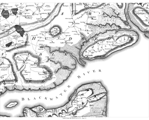
Essex 1773 Sheet 19
The Southminster area
Size: 20.5 x 15.5 inches
Scale: 1.75 inches/mile
Type: reproduction, flat sheet
CLICK MAP TO ENLARGE
PRICE: £9.99
This map shows (spelling as per map) Steple, Tilingham, Dengey, Asheldham, Southminster, Mayland, Althorn, Cricksey, Burnham, Wallasea Island, Paklesham, Potten Island,
& Foulness Island
Essex 1773 Sheet 21
The Barking area
Size: 20.5 x 15.5 inches
Scale: 1.75 inches/mile
Type: reproduction, flat sheet
CLICK MAP TO ENLARGE
PRICE: £9.99
This map shows (spelling as per map) Barking, Dagenham, East Ham, West Ham, Stratford, Leyton, etc.
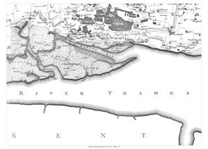
Essex 1773 Sheet 22
Thurrock & Tilbury to Hornchurch area
Size: 20.5 x 15.5 inches
Scale: 1.75 inches/mile
Type: reproduction, flat sheet
CLICK MAP TO ENLARGE
PRICE: £9.99
This map shows (spelling as per map) Hornchurch, Upminster, Cranham, Dunton, Bulvan, Langdon Hill, Corinham, Horndon on the Hill, Stanford le Hope, North Okendon, South Okendon, Wenington, Aveley, Stifford, Orset, Mucking, East Tilbury, West Tilbury, Chadwell, Little Thurrock, Greys Thurrock, West Thurrock, Purfleet... etc,
Essex 1773 Sheet 23
Canvey Island & Pitsey to Prittlewell area
Size: 20.5 x 15.5 inches
Scale: 1.75 inches/mile
Type: reproduction, flat sheet
CLICK MAP TO ENLARGE
PRICE: £9.99
This map shows (spelling as per map) Pitsey, Buers Gifford, Thundersley, South Bemfleet (that's what it says!), Hadley, Eastwood, Prittlewell, Sutton, Shopland, Southchurch, Southend, Lee, and Canvey Island