OLD TOWNS BOOKS & MAPS
Old Maps of Berkshire
Essentials for Local Historians, Genealogists & Family Historians
MODERN MAPS
LOOKING FOR A DETAILED MODERN ORDNANCE SURVEY MAP OF A BERKSHIRE TOWN? CLICK HERE
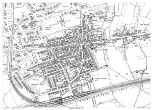
Scale: 28 inches to the mile
Size: 21.5 x 15.25 inches
CLICK MAP TO ENLARGE
Showing the area from Kidwells Park in the north to the railway station by Grenfell Park in the south, and from Castle Hill in the west to Moor Arches in the east.
High Street / Bridge Street runs west to east across the map centre.
A large, brand new modern reprint
A FLAT-SHEET MAP (not folded)
SENT NEXT WORKING DAY
ROLLED IN A CARDBOARD TUBE
Full size 300dpi PDF format.
Instant secure download at purchase
View in Adobe Reader or similar software.
Zoom in for amazing detail.

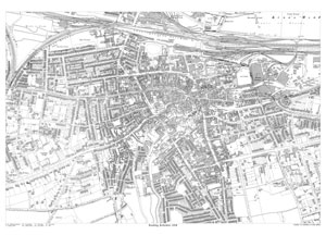
Scale: 14 inches to the mile
Size: 21.5 x 15.25 inches
CLICK MAP TO ENLARGEShowing the area from the Great Western Railway Works in the north to beyond St. Saviour's Church in the south, and from All Saints Church in the west to the Royal Berkshire Hospital in the east.
A large, brand new modern reprint
A FLAT-SHEET MAP (not folded)
SENT NEXT WORKING DAY
ROLLED IN A CARDBOARD TUBE
Full size 300dpi PDF format.
Instant secure download at purchase
View in Adobe Reader or similar software.
Zoom in for amazing detail.
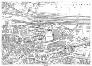
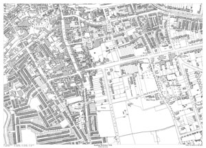
Reading in 1898 - northeast area
Scale: 28 inches to the mile
Size: 21.5 x 15.25 inches
CLICK MAP TO ENLARGEShowing the area from Kings Meadow in the north to Queens Road in the south, and from Gun Street in the west to the Sewage Pumping Station in the east.
A large, brand new modern reprint
A FLAT-SHEET MAP (not folded)
SENT NEXT WORKING DAY
ROLLED IN A CARDBOARD TUBE
Full size 300dpi PDF format.
Instant secure download at purchase
View in Adobe Reader or similar software.
Zoom in for amazing detail.
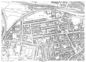
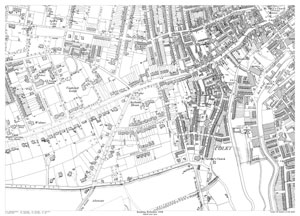
Scale: 28 inches to the mile
Size: 21.5 x 15.25 inches
CLICK MAP TO ENLARGEShowing the area from the Fair Ground & cattle Market in the north to Baker Street in the south, and from Gower Street in the west to St. Mary's Church in the east.
A large, brand new modern reprint
A FLAT-SHEET MAP (not folded)
SENT NEXT WORKING DAY
ROLLED IN A CARDBOARD TUBE
Full size 300dpi PDF format.
Instant secure download at purchase
View in Adobe Reader or similar software.
Zoom in for amazing detail.
Scale: 28 inches to the mile
Size: 21.5 x 15.25 inches
CLICK MAP TO ENLARGEShowing the area from Queen's Road in the north to Edgehill Street in the south, and from Katesgrove Lane in the west to the Royal Berkshire Hospital in the east.
A large, brand new modern reprint
A FLAT-SHEET MAP (not folded)
SENT NEXT WORKING DAY
ROLLED IN A CARDBOARD TUBE
Full size 300dpi PDF format.
Instant secure download at purchase
View in Adobe Reader or similar software.
Zoom in for amazing detail.
Scale: 28 inches to the mile
Size: 21.5 x 15.25 inches
CLICK MAP TO ENLARGEShowing the area from Baker Street in the north to Berkeley Avenue in the south, and from Brunswick Street in the west to Fobney Street in the east.
A large, brand new modern reprint
A FLAT-SHEET MAP (not folded)
SENT NEXT WORKING DAY
ROLLED IN A CARDBOARD TUBE
Full size 300dpi PDF format.
Instant secure download at purchase
View in Adobe Reader or similar software.
Zoom in for amazing detail.
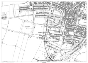
Scale: 28 inches to the mile
Size: 21.5 x 15.25 inches
CLICK MAP TO ENLARGEShowing the area from South Meadow in the north to Bexley Street in the south, and from St. Andrew's Church in the west to Windsor Bridge in the east.
A large, brand new modern reprint
A FLAT-SHEET MAP (not folded)
SENT NEXT WORKING DAY
ROLLED IN A CARDBOARD TUBE
Full size 300dpi PDF format.
Instant secure download at purchase
View in Adobe Reader or similar software.
Zoom in for amazing detail.
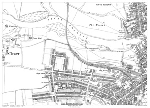
Windsor in 1897 - Clewer Within area
Scale: 28 inches to the mile
Size: 21.5 x 15.25 inches
CLICK MAP TO ENLARGEShowing the area from Bexley Street in the north to Osborne Road in the south, and from Green Lane in the west to Love Lane in the east.
A large, brand new modern reprint
A FLAT-SHEET MAP (not folded)
SENT NEXT WORKING DAY
ROLLED IN A CARDBOARD TUBE
Full size 300dpi PDF format.
Instant secure download at purchase
View in Adobe Reader or similar software.
Zoom in for amazing detail.
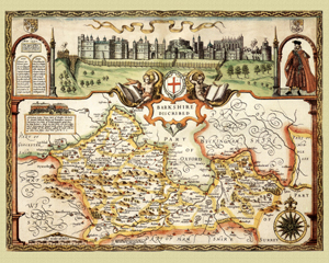
Berkshire in 1610
by John Speed
Size: 16 x 20 inches
GO TO THE JOHN SPEED PAGE